
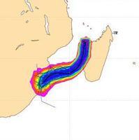
Northern KZN can expect heavy to torrential rain from Sunday through to Tuesday, as Tropical Storm Irina makes her way along the coast. Having come to life over the ocean, east of Madagascar, the storm is likely to bring conditions last seen during Domoina in 1984.
The South African Weather Service predicts rainfall of 300 to 400mm over 2 to 3 days, with accompanying marine storm surge (a local sea rise of sea level in close proximity to the core of the tropical storm) as well as gale-force winds.
Areas particularly at risk would be the southern coast and adjacent interior of Mozambique, between Inhambane and Ponte do Ouro, extending down to include the Maputaland coast and adjacent interior of extreme north-eastern KwaZulu-Natal. Kosi Bay, St Lucia and Richards Bay are thus considered to be well within the high risk region.

The remainder of KwaZulu-Natal and Swaziland could easily experience 100 to 200mm of accumulated rain during the period Sunday to Tuesday, with a danger of flash flooding and localised washaways as rivers and dams are pushed beyond capacity.
The public are therefore urged to be extremely cautious and (if possible) to avoid crossing swollen rivers, either on foot or by vehicle.
Forecast for the week (Kloof)
Sunday: min 22/max 27, 89% chance of rain
Monday: min 19/max 24, 70% chance of rain
Tuesday: min 18/max 24, 16% chance of rain
Wednesday: min 17/max 26, little chance of rain
South African Weather Service – www.weathersa.co.za

What common-sense precautions should I take?
- Avoid crossing strongly-flowing / flooded rivers at causeways or drifts (this advice is equally valid for pedestrians as well as motorists).
- Dwellings very close to rivers or within floodplains should be evacuated timeously (Farmers would be best advised to move river water pumps to higher ground).
- Small to medium sized boats and fishing craft (operating along the coastline mentioned above) should return to port timeously.
- Small fishing boats should be moved well above the normal high-water mark and firmly secured, as storm surge can be expected to raise local sea-levels by as much as 15 to 18 feet (3 to 6 m), particularly on the southern (poleward) side of the tropical storm.